|
|
Washington Publishers |

Antilles
 Antilles Flag Image Source: Wikipedia.org |
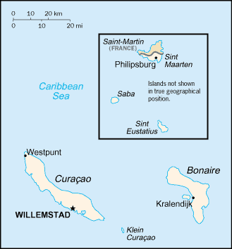 Antilles Map Image Source: CIA World Factbook |
The Antilles now generally refers to the islands of the Caribbean except the Bahamas. A distinction is made between the "Greater Antilles" on the north of the sea, including Cuba, Jamaica, Hispaniola (Haiti and Dominican Republic), and Puerto Rico; and the "Lesser Antilles" on the east, forming the Leeward Islands, the Windward Islands, and the Venezuelan Islands—the Leeward as far as Dominica, the Windward as far as Trinidad, and the Venezuelan along the coast of South America. Because of their linguistic similarities with Spanish-speaking nations, Cuba, Dominican Republic and Puerto Rico are also considered part of Latin America. Geographically speaking the Antilles are part of North America. source: wikipedia.org |
Copyright © 2000 - 2009 All Rights Reserved Washington
Publishers
This web page is best viewed in 1024 x 768 resolution.
Last updated April 2009. Over 1,194,000 page views.
This web site is maintained by Washington Publishers, Tallahassee Florida,
USA, and uses Sun Domains and Software.
To have objectionable or potentially copyrighted material evaluated
for removal on this site, click
here.
Washington Publishers is not an affiliate of Inside
Washington Publishers.
Learn more about our current privacy
and information practices.